London Before London and DNA

Photo of the Petrous part of the temporal bone

I have just given a guided walk and a virtual tour of London in the prehistoric period. I rashly promised, as follow-up, a booklist. I have many books that I have found pivotal in shaping my own opinions, but I find myself very reluctant to recommend them in the light of the remarkable new, and recent, DNA discoveries.

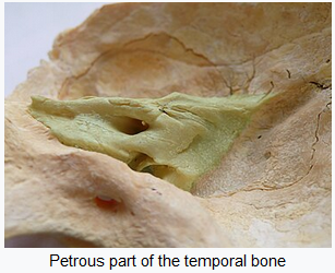
The cause of this ‘revolution’ is the Petrous Bone – a small bone in/near the ear from which scientists can extract, without too much damage to ancient skeletons, a reliable source of ancient DNA. Previous studies were done on modern DNA and extrapolating backwards. Now, archaeologists can, relatively cheaply, investigate (and often debunk) archaeological theories about the spread of human cultures.

It is a salutary story. Early archaeologists had, what you might call, a colonial, diffusionist model of the past. So when a new culture was identified, normally on the back of the arrival of a new form of pottery. It was interpreted as being spread by diffusion, normally from the ‘civilised’ fertile crescent to barbaric pre-literate Europe. Hence, Stonehenge was thought to be built by a prince from Mycenae, on the basis of the Lion Gate in Mycenae having vague similarities with the Trilithons at Stonehenge (and other diffused cultural markers). And with a viewpoint, that the uncivilised Britons would not be able to build something so amazing!

Archaeologists in the 1970s rejected this imperialist model and preferred to think that cultures need not depend on advances from their betters, nor should ‘invasion’ be allowed to be the main means of technical and cultural advancement. The advent of Radio Carbon Dating profoundly affected how the past was dated, and showed that diffusionist chronologies, often, did not stand up. And thus Stonehenge was freed from cultural imperialism, and we Brits could take all the credit. And Prehistory lost a whole host of ‘invasions’ and ‘migrations’, and a start was also made on diminishing the centrality of the ‘invasions’ at the core of the Anglo/Saxon/Viking migrations into Briton.

Along comes the petrous bone and the development of the study of Ancient DNA, and we discover, in the last couple of years, that:

  1. The ancestors of Britons were dark to black skinned
  2. Farming was indeed introduced from the Continent, around 4000BC and the DNA of the UK was largely (but not completely) replaced by incomers. So it was not the Mesolithic hunter gathers who adopted farming but the ‘Western Neolithic’ people who settled bringing in sheep, cows, goats, pigs, wheat, oats, rye, barley, polished axes and pottery.
  3. The Beaker Folk, DNA now tells us, came from abroad around 2,500 BC. Originally from the Steppes via the Netherlands, and their DNA replaced all but 10% of the Western Neolithic DNA. This happened at about the same time as Stonehenge was remodelled with the giant Trilithons.
  4. Another influx of people from around 1300BC to 800BC replaced around 50% of the DNA of Britain.

So we now have at least 3 major population replacements before the coming of the Romans, Saxons, Vikings and Normans. Very annoying to find that those old-fashioned imperial archaeologists of the early 20th Century had it more correct than the enlightened archaeologists of the Late 20th Century.

London before the Romans
View of London from the SE as it might have looked before the Roman Invasion

So to my book list. Firstly, you will have noted above that I have linked the stories to reliable websites, so you can get further information. Here are a few other important websites:

Neolithic Houses at the Horton site at the Wessex archaeology site

Archaeology of Heathrow Terminal 5 https://framearch.co.uk/

Bronze Age Bridges at Dorney: https://heritageportal.buckinghamshire.gov.uk

Vauxhall Mesolithic and Bronze Ages Structures: https://www.vauxhallandkennington.org.uk/

Principle Place Feasting Site?: https://www.independent.co.uk/

Hill forts in the London Area: https://hillforts.arch.ox.ac.uk/

As to books, I suggest the best start is to read Mike Parker Pearson’s ‘Stonehenge A Brief History, Bloomsbury Academic 2023’ because it is up-to-date and Pearson has considered the DNA studies noted above.

For similar reasons and for a more general introduction to Britain in the Prehistoric period, you could try:

Roberts, Alice ‘Ancestors: A Prehistory Of Britain In Seven Burials ‘ Publisher: Simon & Schuster Ltd 2022

which has good reviews, but I have not yet read it.

I know that neither is about London, but the only ‘book’ on Prehistoric London I have is:

Merriman, N ‘Prehistoric London’ Museum Of London, 1991

And this is more of a booklet than a full academic book. There is another book, but then it was published in 1914:

Prehistoric London : its mounds and circles / by E.O. Gordon ; with appendices by John Griffith. Volume c.1 1914

For the period just before the Roman Invasion, I would highly recommend reading Julius Caesar’s opinions on Prehistoric Britain.

Caesar, Julius (ed Anne & Peter Wiseman). ‘The Battle For Gaul’ Chatto And Windus Ltd, London 1989

Peter Wiseman was my Professor at University, and it is an excellent introduction, still available new but also cheaply second hand at Abebooks.

You will find some interesting, relevant passages in my book:

Flude, Kevin ‘In Their Own Words – A Literary Companion To The Origins Of London’ D A Horizons, 2009

You can buy a hardback copy from me for £5 plus postage (email me, kpflude@chr.org.uk) or from Amazon in a Kindle version.

I will add more as I find them!

Cover of Kevin Flude's 'In their Own Words'
A Literary Companion to the origins of London

All Hallows Day, Day of the Dead, Dia de Muertos, Dia de Todo Los Santos, Halloween

I have updated my November 1st Post to include, among other improvements, new pictures of the Day of the Dead in Mexico.

The End of Hardy’s tree

From the Guardian Article

I published the following post about Hardy’s Tree on 28th December 2022. Here, follows the original post and an update which suggests the tree and the gravestones were not erected by Thomas Hardy.

This is the day that Herod ordered the slaughter of the Innocents, or Childermas, and I am glad to see that my Grandson is now older than Herod’s prescription.

Hardy’s Tree in St Pancras Church, Camden, London has fallen down. Hardy was an architect and worked in London for a while, where one of his jobs was to supervise the clearance of the graveyard. Several poems of Hardy refer to the removal of graves from their original positions and in this case, the gravestones were set around an Ash tree that inspires many, including my Central St Martin’s students who used it in a project recently. So, I was shocked to read a Guardian article (since deleted) which noted the sad demise of the Tree.

Extracts from one of several Hardy Poems about moving graves and gravestones follow, but I need to update the post about the connection to Hardy. The Guardian has now got an article which suggests the connection with Hardy is a more recent one than previously thought (Guardian article).

I (and I think the Guardian) were alerted to this by the work of Lester Hillman, who wrote a Churchyard Guide and a recent pamphlet about the Tree, which is reported in ‘Context ISSN 1462-7574’. This is the Journal of the City of London Archaeological Society. Evidence proves that the Ash Tree dates to the 1930s, and that the mound of gravestones is from burials relocated from St Giles in the Fields, and therefore unlikely to have been in St Pancras at the time Hardy was responsible for clearing it.

So it is not ‘the’ Hardy Tree, but then nor was the tree at Sycamore Gap anything to do with Robin Hood. What it was, was a beautiful piece of nature, in a poignant setting. May she rest in peace.

The Levelled Churchyard
Thomas Hardy

O Passenger, pray list and catch
Our sighs and piteous groans,
Half stifled in this jumbled patch
Of wrenched memorial stones!

We late-lamented, resting here,
Are mixed to human jam,
And each to each exclaimed in fear,
I know not which I am.

Where we are huddled none can trace,
And if our names remain,
They pave some path or porch or place
Where we have never lain!

Fury in France at Destruction of 7,000 Year-Old Standing Stones June 2023

Salon IF reported a shocking destruction in France – this is the report, verbatim from Salon IF issue 514.

Dozens of standing stones, erected over 7,000 years ago, have been demolished to make way for a DIY store near Carnac, in Brittany, in North West France. Some 37 stones, measuring between 0.5 – 1.5m tall, were removed despite the fact the site had long been on France’s National Archaeological Map. The stones, moreover, had been submitted to the tentative list of UNESCO World Heritage Sites (although the application had not yet been approved).

The region of Carnac is famous for its ancient ‘menhir’ – heavy, raised standing stones. Indeed, the area is often described as ‘the French Stonehenge’, with over 3,000 stone megaliths at the two sites of Menec and Kermario. There, the stone columns are arranged in long, straight rows and, according to the Carnac Tourist Office, it is the largest gathering of this type of standing stone in the world.

The land at the centre of the recent controversy, along the Montauban activity zone, had been granted a building permit by the local mayor’s office in August 2022 and construction of the new store, ‘Mr Bricolage’, was already underway. According to local amateur archaeologist, Christian Obeltz, who had originally raised concerns about the ‘brutal developments’, a bulldozer destroyed the stones overnight.

The Regional Office of Cultural Affairs for Brittany, the body responsible for the protection of the monument, said ‘Given the uncertain and in any case non-major character of the remains, as revealed by

checks, damage to a site of archaeological value has not been established’, but Obeltz maintains that archaeological investigation into the area had not been sufficient.

‘The Chemin de Montauban site included two intersecting rows of small granite stelae, each spreading out over fifty meters in length. One had been exactly in its original place for 7,000 years,’ according to Obletz. ‘The small menhirs of the Chemin de Montauban were undoubtedly one of the oldest sets of stelae in the town of Carnac’ believed to date between 5480 and 5320 BC, ‘the highest dating obtained for a menhir in the west of France’.

Ascension Day beating the bounds

This year it is May 28th

Here, is an interesting account from the web site of the Historic Royal Palaces about marking the boundary of a Parish in the ceremony known as ‘beating the bounds’.

https://blog.hrp.org.uk/beating-the-bounds/

Digital Heritage – The Past Deciphered by AI

This is one of the most exciting advances I have read about for a long time! A pile of burnt scrolls survive from the Villa dei Papiri, Herculaneum. They are being examined by several teams from American Universities including the University of Michigan, and the University of Kentucky. They are just beginning to read fragments of the texts, using all the scientific techniques they can throw at it including AI. The AI has begun to learn to read fragments of the tightly rolled scroll.

Burnt Scroll
Burnt Scroll

The scroll they are working on appears to be a piece about Alexander the Great and his legacy. It is an unknown text or to put it another way, it is potentially a brand new source of information for this period of time. It has been suggested that it might possibly be a copy of the lost diary of Alexander’s secretary, Eumenos or may have been written by a friend of the general Antigonos.  Either way, potentially eye witness accounts. Or not, as perhaps, they may be asking too much from the first investigation. It may be more prosaic. Time will tell.

The implications, however, are so exciting! Just as the amazing excavations at Stonehenge (and indeed in London) have revolutionised our knowledge of these places, so AI could introduce completely new insights into the past. There are many rolls that were burnt in the collection, but now AI is beginning to read them. what insights we might get even from small fragments? One of the scholars involved is particularly excited to imagine the discoveries that could be forthcoming from the Middle East

‘While others would love to see some of the lost work of the ancients, what I’d like to see is evidence of the turmoil that was happening in the first century around the development of Christianity and the Judeo-Christian tradition as it was evolving.’

Brent Seales, University of Kentucky

Part of scroll unfolded

But those ‘lost works of the ancients’. There are so many that would rock history: Tacitus’s ‘Annals’ missing missing the last two years of Nero’s reign. Pytheas ‘On the Ocean’ with its first references to Britain in writing. 6 Plays of Aeschylus, 9 Books of Sappho and the list goes on. Have a look at Charlotte Higgins piece in Prospect Magazine for a little more detail.

Another feature of the study is that the teams have released images to the cloud and are encouraging others to ‘have a go’ at reading them. This shows the strides that Citizen Science has made, and how, scientists acknowledge that, in the days of big data, cooperation pays huge dividends.

My source of information is the marvellous The Society of Antiquaries of London Online Newsletter (Salon) which ‘is a fortnightly digest of heritage news‘ and for more information look at Issue 509.

Another source is Interestingengineering.com.

Testing 360deg

I’m testing a new 360 degree plugin

Brussels 4 Best to read the better proof-read version

I was a hurry to get it finished. So if you haven’t read it read it yet this updated version makes more sense and has some extra details:

Town exploration: 4 Brussels

Modern map of central Brussels.  The Bourse is a red circle near the centre.

The map of the centre of Brussels shows the area where I have identified topographical evidence of an early Wall circuit. The two red lines coming from the top left point to a red rectangle which is on the curved road called ‘Vieux Marché aux Grains’. This road follows the curved line of the NE section of the wall and was confirmed by the discovery of a surviving section of the Wall on it (see previous posts).

So, on my 4th and last day in Brussels I want to find the rest of this circuit. If you look at the map you can convince yourself there is a circular route – Rue des Riches Clares (Street of the Clare nuns); Rue des Teinturies (Street of Dyers); Kolenmarkt (Coal Market) and to the Grand Place. But I can find nothing that proves it and its a bit weird to have the Town Square (Grand Place) of the town outside the circuit. Maybe this is because the Bourse was the original centre of gravity I wondered? Whatever the case, the roads have the irregularity of medieval town centre streets.

The Town  Hall Grand Place, Brussels
The Town Hall Grand Place, Brussels

It started to rain so decided to see about a guided tour of the Town Hall, but the attendant suggested I’d be better off at the free ‘House of the King’ across the square which I discover with rising excitement is subtitled ‘The Brussels City Museum.’ Initially I’m disappointed as it is full of fragments of Gothic statues, but upstairs, I strike pay dirt with not only maps, engravings and photographs of the Old Wall Circuit but also a massive model.

Model of 13th Century Wall Circuit of Brussels.
Model of 13th Century Wall Circuit of Brussels. (looking South West)

It takes me a lot of time to work out what is what and which direction we are looking. But the section of the wall at the bottom of the photo above is the wall I identified on the Vieux Marché aux Grains. St Catherine’s is the Church seen just inside the Wall, just to the left of the Gate at the middle bottom of the photo. Other evidence makes it clear that the present day St Catherine’s was moved a little to the left (east).

So, a confirmation of sorts, but also a revelation, in that a river is flowing just behind the wall, and the wall circuit is much bigger than I suspected.

The River is the Senne, it was navigable to an extent taking 8 days to take cargoes to the River Schelde. The River is completely gone, and I think the other part of the wall I pencilled in was actually not the wall but roads following the route of the River.

The River Senne, originally the reason for the foundation of Brussels, became a stinking sewer and was filled in leaving no trace, except the roads that ran alongside it or replaced it.

Detail labelled copy of panoramic painting of Brussels c1665 by Jean-Baptiste Bonnercroy.  Looking South West

The River was augmented and then replaced by a Canal, which reduced the journey time to the Schelde to one day. The Canal came into the expanded City at no 29 (above_ which is the River gate of the 2nd Wall circuit, and, you might just be able to see a wide street going diagonally from 29 towards no 26, which is St Catherine’s Church. This street used to be the new canal, now a dry linear park and market place.

Detail of Braun & Hogenberg map of 1572, showing the canal entering at Porte De Rivage.

At the end of the canal was a T-Junction so that boats could turn around. When this was filled in and reclaimed St Catherine’s was moved and rebuilt in this space. The Wall was just south of the t-Junction and No 30 in the panorama is the Black Tower, part of the original 13th Century Wall Circuit.

St Catherine’s, built over the old t-junction of the canal. The photo is taken from what was once the canal.

But back to my search for the 13th Century Walk circuit. Look below at the whole model you will see how wrong I was about a small roundish early wall circuit.

Model of 13th Century Wall Circuit of Brussels.

This view of the town is the opposite direction to the previous one, so the wall in the far distance was the section I correctly identified. But I had absolutely no idea that the walled area was so large. The bulge in the wall at the front of the picture was on high ground and was original the site of the Duke of Brabant’s Castle, on Coundenberg Hill and founded in the 11th Century. My exploration was not particularly successful, as far as the 13th Century circuit was concerned, as I had no idea where most of the wall circuit was. I was thinking that there must have been a castle on top of the Hill, but didn’t think the wall circuit would be that big.

Brussels itself began as a small trading town on the River Senne and in the marshy valley of the River. It collected grain from the rich area to export to Antwerp and other urban centres.

Braun and Hogenberg Plan of Brussels, 1572 showing both wall circuits. North east at the bottom of the plan

The map above shows the two wall circuits. The earliest built 1210 -1230 and the large circuit built in 1357 -1383. That later was extensively developed with the addition of demi-lunettes in 1578, and turned into full bastions in 1671 to cope with the increasing power of artillery. The letters on the plan refer to pictures of the wall that survive.

Panoramic painting of Brussels c1665 by Jean-Baptiste Bonnercroy.  Looking South West

The second wall circuit can clearly be seen in the picture above, with Porte de Flandres in the centre, and demi-lunettes in front of the 14th Century Wall.

I finished the exploration by finally getting into the 14th Century Gate – Porte de Halle which was wall worth the two trips.

Porte de Halles

This image below will give a good idea of the final form of the defences before they were almost totally demolished and replaced by a ring road.

The late 17th Century Defences of Brussels.

So all in all Brussels is a very interesting City with great museums, amazing pubs/bars, fabulous remains of Art Nouveau dotted around, and an interesting history. As to my exploration, very enjoyable, a little disappointed I didn’t find the River, or identify more of the 13th Century Circuit. With another day I would have walked the entire 13th and 14th Century circuits. But I suspect the surgeon who did my hernia operation would have thought I overdid it as it was.

Town exploration: 3 Brussels

modern map of central Brussels.  The Bourse is a red circle near the centre.

So my next task is to confirm the earlier wall circuit on the map. 

To remind you I have tentatively identified the street called the’ Vieux Marché aux Grains’ as a section of an earlier wall circuit surrounding Brussels.  On the map above the two red lines coming from the top left point to a red rectangle which is on the Vieux Marché.  Walking along it you soon come to a beautiful church dedicated to St Catherine.  It must be either just inside, just outside or on top of my walk circuit.

St Catherine’s, Brussels

I walk into the church, photograph lots of saints and walk out and there just beyond it is the confirmation that I’m right.  There is a beautiful interval Tower and, just to make it certain, it has sections of wall coming out from it.  So this the earlier wall circuit.  Looks medieval, a century or two earlier than the Porte de Halles.

The Black Tower, Brussels

So, I’m feeling pleased with myself.  Two wall circuits confirmed, the outer one I know where the entire circuit is and that it has all been swept away and replaced by an urban ring road except a couple (?) of fragments.

The inner circuit I have only confirmed one section, I know one more bit of it exists or did exist but pretty sure not much else.  I’m thinking from the street pattern that it is a small roundish circuit, but nothing is clear from the street pattern apart from this one street.

Feeling smug although I am aware this is a strange game I play with myself.  I could just Google ‘Brussels Town Walls’ and I would have most of the answers instantly but the fun of the game is to find it out yourself through topographical clues. 

I do it, I think, partly to honour my friend, David Bentley, who died of motor neurone disease a good few years ago but not before we had many stimulating discussions on topographical clues to urban history.  Also, it really helps you understand the City, it will tell you why particular roads are important, and give the history of the growth of the town.  Since I lost David it is often a solitary game as it needs a very tolerant person to put up with following leads to frequent dead ends and someone who can share the thrill of finding a small fragment of ‘wall’ in exactly the predicted place.

One more discovery before I end.  There is a linear ‘park’ coming down from the Porte Flandres, it is lined with what remind me of canalside houses in Bruges, and this seems to be the original route of the canal that was built to link Brussels to the Scheldt.  I was told that the canal was diverted when they built the new walk circuit so this seems to be the original course.  It comes down to the side of St Catherine’s.

Filled in Canal leading to St Catherine’s.  Fish restaurants to the right and you can just see the Black Tower to the left of the Church.

I have no idea how the boats turned around but the grain market was to the right and the fish restaurants suggest this is where fish were landed.

Tomorrow, you will find out if my smugness is confirmed after I decide it is time to  check the facts and leave speculation behind.