Martinmas was a very important part of the medieval Year, marking as it did the end of Summer, and the beginning of Winter.
I have been updating a series of Martinmas posts which you will find below:
And finally, a saintly repost:

The Past brought to Life
Martinmas was a very important part of the medieval Year, marking as it did the end of Summer, and the beginning of Winter.
I have been updating a series of Martinmas posts which you will find below:
And finally, a saintly repost:

Traditionally, Yarrow has a myriad of uses (see thefreedictionary for a comprehensive list). It was used for wounds (aka ‘Soldier’s Woundwort’); staunches nose bleeds (aka ‘Nosebleed’); inflammations …. THE PAGE HAS BEEN TRANSFERRED TO A NEW NOVEMBER 13TH PAGE HERE.
Post First published on 14 November 2022, revised 13 November 2023 and transferred to new page on 13th November 2024

A late warm patch is now often called an ‘Indian Summer’. This term was first used in the United States in the 19th Century and may refer to a warm period in which Indigenous Americans could continue hunting.
Previously, in England, a warm patch in the Autumn was called a ‘St Martin Summer’ or ‘a Halloween Summer.’ St Martin’s Day is the 11th November, and is, in a normal year, the day around when the weather turns to feel wintry.
A warm spell is, in fact beneficial to many plants. The problem comes if it is followed by a quick cold spell. Plants need time to harden off to prepare to face cold weather. A warm winter will also allow a lot of insects to survive and so in the summer plants will be adversely affected by a plague of pests.

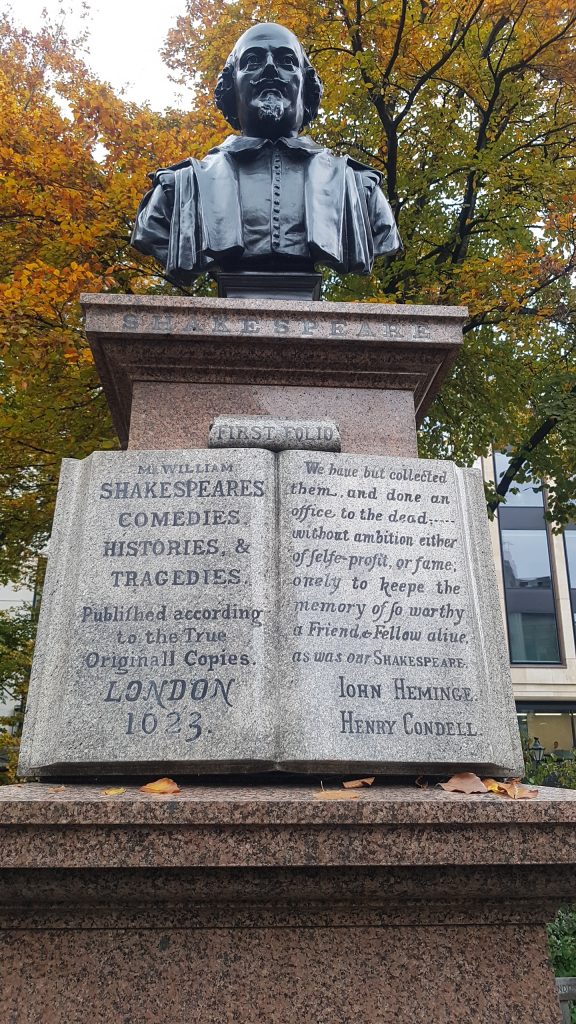
Four Hundred and One Years ago, on 8th November in 1623, the First Folio was registered at Stationer’s Hall near the publishing district around St Pauls Cathedral in London. It was actually called:
Mr. William Shakespeare’s Comedies, Histories, & Tragedies
It was put together by his actor friends, John Heminge and Henry Condell seven years after his death, and they wanted to replace all the corrupt editions of his plays and poems that had been
“stol’n and surreptitious copies, maimed and deformed by frauds and stealths of injurious impostors”.
The true texts of his plays and poems “are now offer’d to your view cured, and perfect of their limbes; and all the rest, absolute in their numbers as he conceived them.” Wikipedia
In fact, the plays were ready early as they entered in to the catalogues for the Frankfurt Book festival to appear between April and October 1622,- and how amazing is it that, that festival is still the dream of any aspirant writer?
The First Folio offers plenty of proof that Shakespeare was the author of the plays. He left gold rings of remembrance to Heminge and Condell in his Will. They were part of his Players Company, and had worked together on many of the plays. The Folio has forewords by people extolling the virtues of the writer. Enough proof for any reasonable person.
Heminge and Condell are commemorated in the Garden of St Mary Aldermary behind the Guildhall, where they were Churchwardens, and not far from where Shakespeare was living in 1611. True friends.
There was a wonderful BBC festival of Shakespeare on in 2023/24 to celebrate. Here:
Intersex Day of Remembrance, also known as Intersex Solidarity Day, is an internationally observed civil awareness day. (Wikipedia).
First Published November 2024, Intersex day added Feb 2025. To be completed November 2025
Recent discoveries from Pompeii are being reported in a timely fashion on an interesting website – one of the recent posts is about the discovery of a Roman Electoral Poster. Please enjoy the read! electoral-inscriptions-discovered-in-pompeii
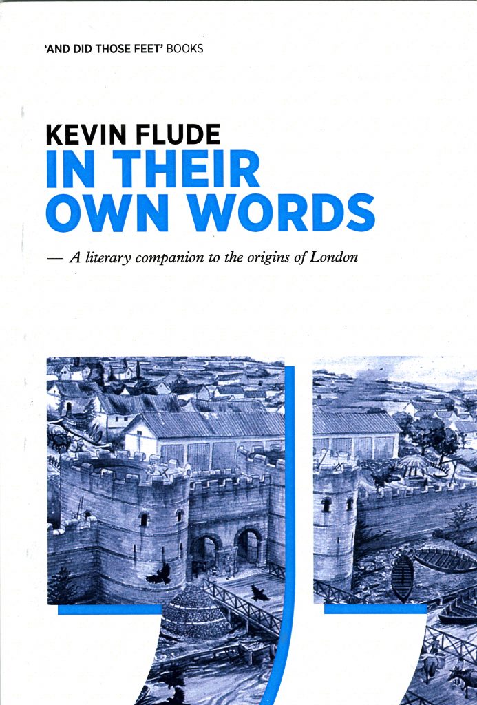
Below, I enclose a short section of my book ‘In Their Own Words – A Literary Companion To The Origins Of London‘ on Roman Elections, which might be of interest. But first, I have updated and republished my Almanac of the Past Blog posts for November 4th and November 5th, which you can see my following these links:
Extract from ‘In Their Own Words – A Literary Companion To The Origins Of London‘ about Roman Local Politics.
The forum in a Roman town was the central meeting place, used for offices, shops, market, meetings and political elections. Inscriptions show that the Londinium forum was the home of the provincial assembly, and that local government in London continued down to the ward (vicus) level. Surviving political `posters’ and graffiti from Pompeii provides some idea of the concerns of the Roman citizens:
Neighbours! Vote L Status Receptus for duumvir. He is fine. Posted by Aemilius Celer Vicinus.
A Plague on any wretch who scrubs this out!
Vote for M Casellius Marcellus ,a good aedile. He will grant great Games!
Bruttius Balbus for duumvir. Genialis supports him. He will conserve the treasury.
Trebius for aedile! The barbers support him.
M.Cerrinius Vatia for aedile! All night drinkers back him. Vatia for aedile! The pick pockets back him!
Spend for the public welfare! Keep the rates down!
— John Morris,‘londinium’22
A duumvir was the chief magistrate of the town, the equivalent of the Consul in Rome, and he was helped by `junior’ magistrates including aediles. As magistrates, they were expected to fund public works and entertainments from their pocket, so they had to be independently wealthy or backed by wealthy interests.
In addition, a property qualification could be imposed. A surviving charter provides:
A councillor of Tarentum…shall possess a building within the borders of the territory of Tarentum that shall be roofed with no fewer than 1,500 tiles.
Voting was strictly controlled, with returning officers, supervision by independent witnesses, and ballot boxes.
In Their Own Words – A Literary Companion To The Origins Of London‘ D A Horizons, 2009. Kevin Flude
To buy Kindle version click here. To buy paperback click on the paypal link below or email kpflude AT anddidthosefeet.org.uk
I have revised the post on All Souls’ Day. If you follow the link you will read about ‘Souling’, Purgatory, and English, Mexican and Polish Customs for 2nd November.
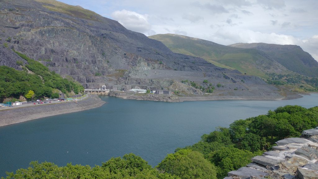
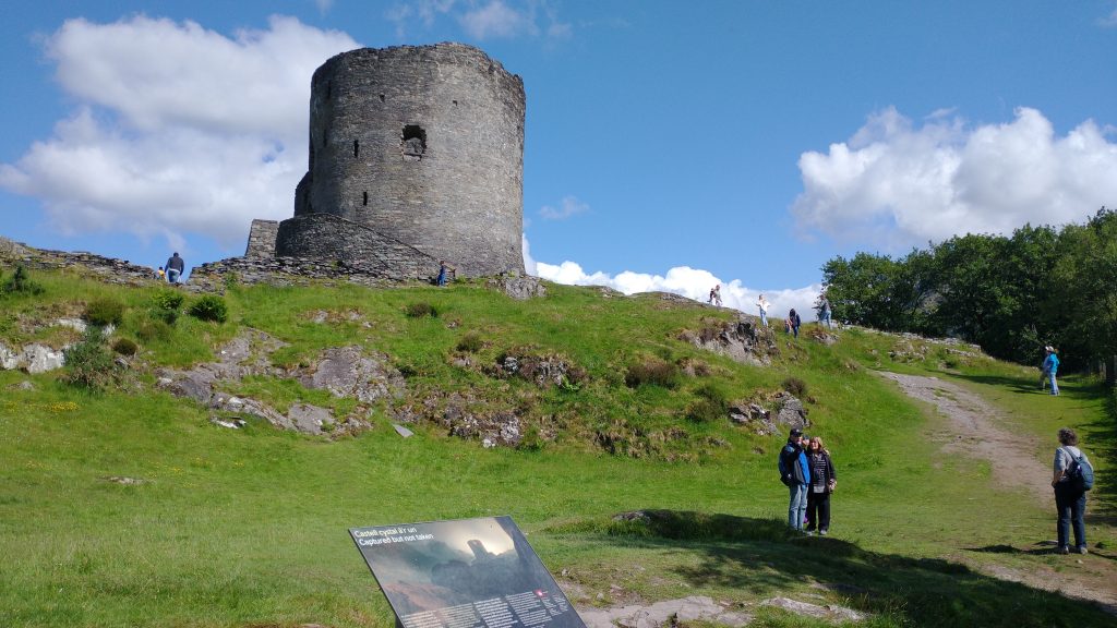
But this post is prompted by an interesting article in the Guardian about the Dinorwig Power Station in North Wales. It’s a place I visit regularly. The photograph is from a Medieval Welsh Castle, Dobaldarn Castle, near the National Slate Museum in the new Unesco World Heritage Site of the Slate Landscape of North West Wales. The photo above gives an idea of the majesty of the destructive power of quarrying for slate.
The Power Station is remarkable. It is a huge cavern in the mountain. When the National Grid has a lot of cheap energy, water is pumped to the top, and when electricity is in short supply, the water runs turbines to provide extra power. It is, in effect, a giant battery, and what makes it even more worthy of a part in a James Bond film is that it has the capability of initiating a Black Start to the Grid. If some cosmic catastrophe turns off the entire grid, Dinorwig can restart the Grid.
The article in the Guardian has some great pictures of it and the text is very interesting. You might want to start reading a third of the way down the article which has a long preamble.
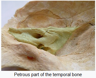
I have just given a guided walk and a virtual tour of London in the prehistoric period. I rashly promised, as follow-up, a booklist. I have many books that I have found pivotal in shaping my own opinions, but I find myself very reluctant to recommend them in the light of the remarkable new, and recent, DNA discoveries.
The cause of this ‘revolution’ is the Petrous Bone – a small bone in/near the ear from which scientists can extract, without too much damage to ancient skeletons, a reliable source of ancient DNA. Previous studies were done on modern DNA and extrapolating backwards. Now, archaeologists can, relatively cheaply, investigate (and often debunk) archaeological theories about the spread of human cultures.
It is a salutary story. Early archaeologists had, what you might call, a colonial, diffusionist model of the past. So when a new culture was identified, normally on the back of the arrival of a new form of pottery. It was interpreted as being spread by diffusion, normally from the ‘civilised’ fertile crescent to barbaric pre-literate Europe. Hence, Stonehenge was thought to be built by a prince from Mycenae, on the basis of the Lion Gate in Mycenae having vague similarities with the Trilithons at Stonehenge (and other diffused cultural markers). And with a viewpoint, that the uncivilised Britons would not be able to build something so amazing!
Archaeologists in the 1970s rejected this imperialist model and preferred to think that cultures need not depend on advances from their betters, nor should ‘invasion’ be allowed to be the main means of technical and cultural advancement. The advent of Radio Carbon Dating profoundly affected how the past was dated, and showed that diffusionist chronologies, often, did not stand up. And thus Stonehenge was freed from cultural imperialism, and we Brits could take all the credit. And Prehistory lost a whole host of ‘invasions’ and ‘migrations’, and a start was also made on diminishing the centrality of the ‘invasions’ at the core of the Anglo/Saxon/Viking migrations into Briton.
Along comes the petrous bone and the development of the study of Ancient DNA, and we discover, in the last couple of years, that:
So we now have at least 3 major population replacements before the coming of the Romans, Saxons, Vikings and Normans. Very annoying to find that those old-fashioned imperial archaeologists of the early 20th Century had it more correct than the enlightened archaeologists of the Late 20th Century.
So to my book list. Firstly, you will have noted above that I have linked the stories to reliable websites, so you can get further information. Here are a few other important websites:
Neolithic Houses at the Horton site at the Wessex archaeology site
Archaeology of Heathrow Terminal 5 https://framearch.co.uk/
Bronze Age Bridges at Dorney: https://heritageportal.buckinghamshire.gov.uk
Vauxhall Mesolithic and Bronze Ages Structures: https://www.vauxhallandkennington.org.uk/
Principle Place Feasting Site?: https://www.independent.co.uk/
Hill forts in the London Area: https://hillforts.arch.ox.ac.uk/
As to books, I suggest the best start is to read Mike Parker Pearson’s ‘Stonehenge A Brief History, Bloomsbury Academic 2023’ because it is up-to-date and Pearson has considered the DNA studies noted above.
For similar reasons and for a more general introduction to Britain in the Prehistoric period, you could try:
Roberts, Alice ‘Ancestors: A Prehistory Of Britain In Seven Burials ‘ Publisher: Simon & Schuster Ltd 2022
which has good reviews, but I have not yet read it.
I know that neither is about London, but the only ‘book’ on Prehistoric London I have is:
Merriman, N ‘Prehistoric London’ Museum Of London, 1991
And this is more of a booklet than a full academic book. There is another book, but then it was published in 1914:
Prehistoric London : its mounds and circles / by E.O. Gordon ; with appendices by John Griffith. Volume c.1 1914
For the period just before the Roman Invasion, I would highly recommend reading Julius Caesar’s opinions on Prehistoric Britain.
Caesar, Julius (ed Anne & Peter Wiseman). ‘The Battle For Gaul’ Chatto And Windus Ltd, London 1989
Peter Wiseman was my Professor at University, and it is an excellent introduction, still available new but also cheaply second hand at Abebooks.
You will find some interesting, relevant passages in my book:
Flude, Kevin ‘In Their Own Words – A Literary Companion To The Origins Of London’ D A Horizons, 2009
You can buy a hardback copy from me for £5 plus postage (email me, kpflude@chr.org.uk) or from Amazon in a Kindle version.
I will add more as I find them!
I have updated my November 1st Post to include, among other improvements, new pictures of the Day of the Dead in Mexico.
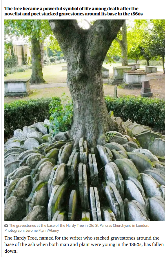
I published the following post about Hardy’s Tree on 28th December 2022. Here, follows the original post and an update which suggests the tree and the gravestones were not erected by Thomas Hardy.
This is the day that Herod ordered the slaughter of the Innocents, or Childermas, and I am glad to see that my Grandson is now older than Herod’s prescription.
Hardy’s Tree in St Pancras Church, Camden, London has fallen down. Hardy was an architect and worked in London for a while, where one of his jobs was to supervise the clearance of the graveyard. Several poems of Hardy refer to the removal of graves from their original positions and in this case, the gravestones were set around an Ash tree that inspires many, including my Central St Martin’s students who used it in a project recently. So, I was shocked to read a Guardian article (since deleted) which noted the sad demise of the Tree.
Extracts from one of several Hardy Poems about moving graves and gravestones follow, but I need to update the post about the connection to Hardy. The Guardian has now got an article which suggests the connection with Hardy is a more recent one than previously thought (Guardian article).
I (and I think the Guardian) were alerted to this by the work of Lester Hillman, who wrote a Churchyard Guide and a recent pamphlet about the Tree, which is reported in ‘Context ISSN 1462-7574’. This is the Journal of the City of London Archaeological Society. Evidence proves that the Ash Tree dates to the 1930s, and that the mound of gravestones is from burials relocated from St Giles in the Fields, and therefore unlikely to have been in St Pancras at the time Hardy was responsible for clearing it.
So it is not ‘the’ Hardy Tree, but then nor was the tree at Sycamore Gap anything to do with Robin Hood. What it was, was a beautiful piece of nature, in a poignant setting. May she rest in peace.
The Levelled Churchyard
Thomas Hardy
O Passenger, pray list and catch
Our sighs and piteous groans,
Half stifled in this jumbled patch
Of wrenched memorial stones!We late-lamented, resting here,
Are mixed to human jam,
And each to each exclaimed in fear,
I know not which I am.Where we are huddled none can trace,
And if our names remain,
They pave some path or porch or place
Where we have never lain!
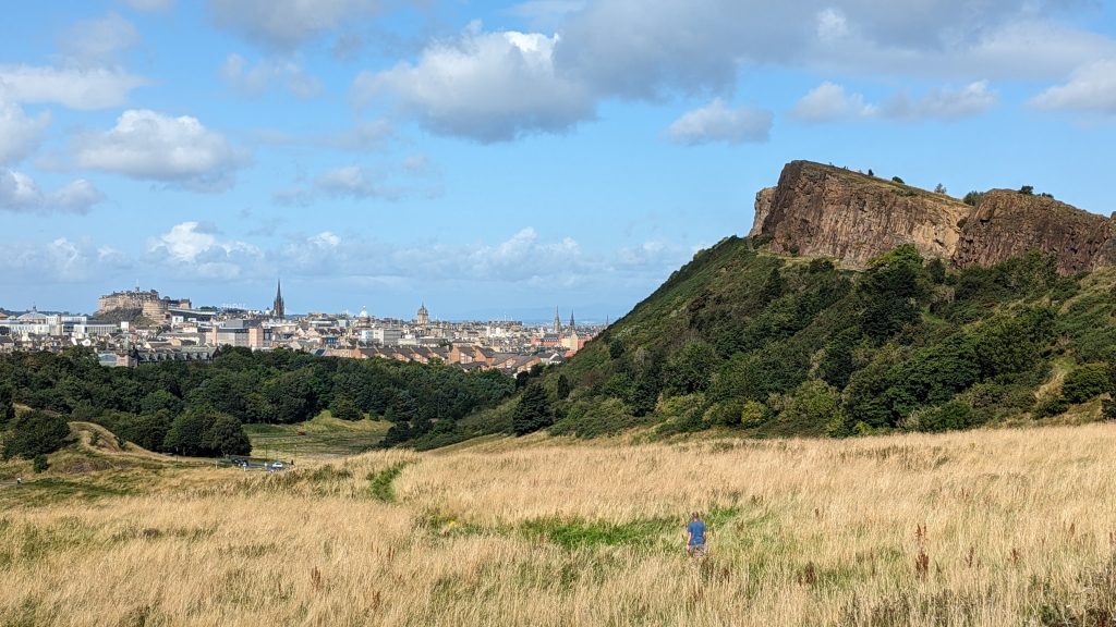
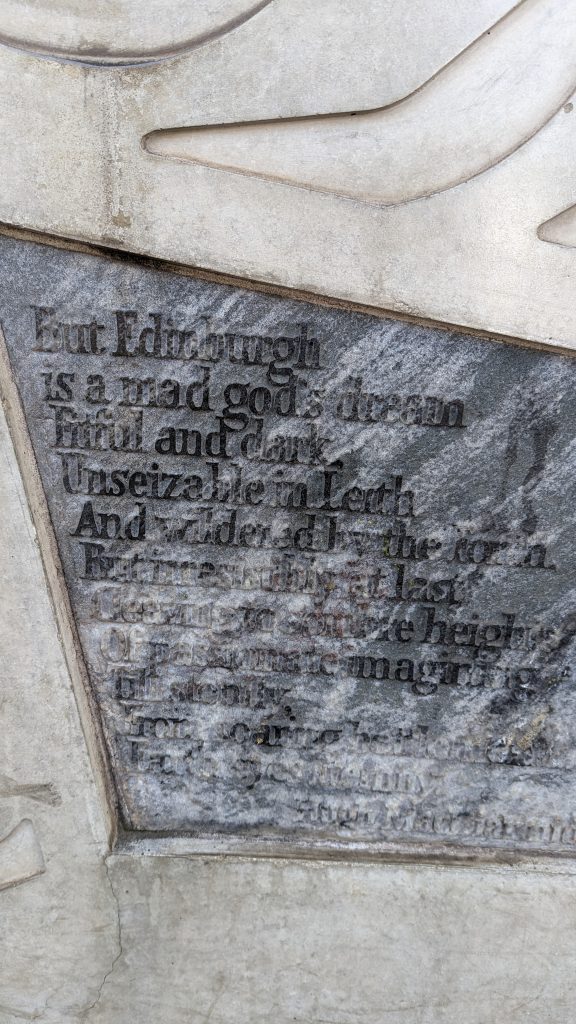
This is a poem which is ‘printed’ on the side of the Scottish Parliament.
by Hugh MacDiarmid
But Edinburgh is a mad god’s dream
Fitful and dark,
Unseizable in Leith
And wildered by the Forth,
But irresistibly at last
Cleaving to sombre heights
Of passionate imagining
Till stonily,
From soaring battlements,
Earth eyes Eternity
Hugh MacDiarmid (1892-1978)